Norfolk
In his History of the QTP (1987) Carr reported three editions, and my assumption that there was a third edition in the 1980s was wrong: there was an earlier edition, in 1967. In an article in The Birmingham Evening Mail on 15th March 1968 (p 18), Carr reported that this was his second published map, after Northamptonshire. Two versions of this 1967 map have been found, one numbered without a denominator and signed, with an additional feature; and one not numbered or signed, but partly printed in colour.
(Last updated on 14/2/2026)
MAP-NOR1: First edition, first impression?
Publisher: 27 Mill Dale Road, Kettering, Northamptonshire Kettering 4495
Year: 1967
ISBN: none
Limitation: none
Size: 310 x 384 mm
Paper: Thin cream card
Colophon: none
Signed: no
Numbered: Yes, no limitation
Proofs where: AH, no. 81
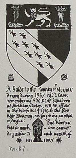
Notes: This map is the same as the version below except that it is printed in monochrome and has what may be reproductions of two brass rubbings in the top left corner, possibly of a man and a woman and their children and. added by hand in silver paint, a small cross 2 cm high. These are missing from the version below, which is assumed to be a second impression. My copy of the map is numbered 87, in pencil, below the shield and dedication.
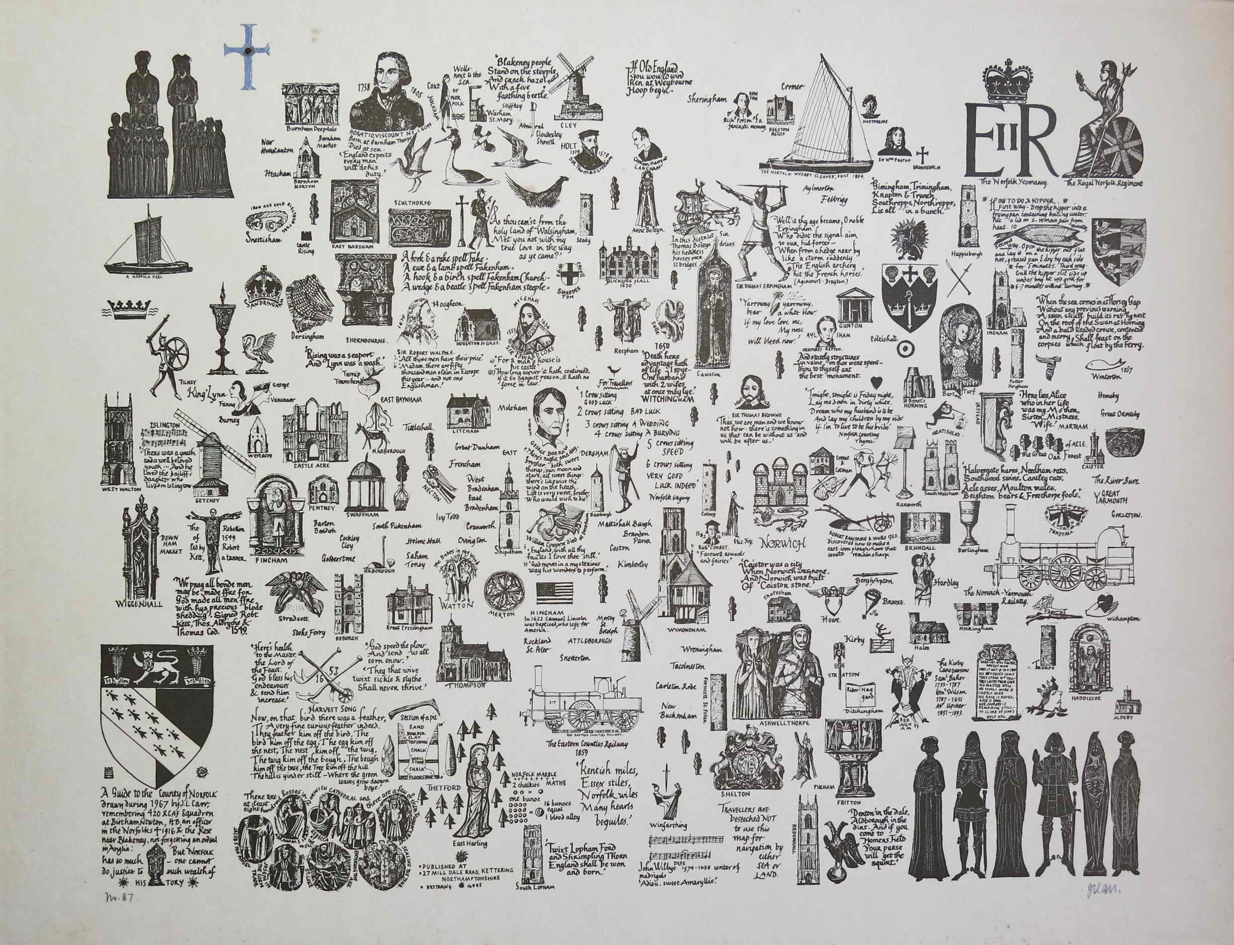
Image of map (click to enlarge)
Detail of dedication (click to enlarge)
This quite small map is described below the shield, lower left, thus:
This Guide to the County of Norfolk drawn during 1967 by J.L. Carr, remembering 420 RCAF Squadron at Bircham Newton, H.B. an Officer in the Norfolks ♰ 1916 & the Rose near Blakeney, but not forgetting an ordeal in Anglia...
The map also states, next to the tower of the church at Redenhall:
TRAVELLERS are beseeched NOT to use this map for navigation by either SEA or LAND.
MAP-NOR1: First edition, second impression?
Publisher: none stated
Year: 1967
ISBN: none
Limitation: none
Size: 310 x 381 mm
Paper: card, laid down
Colophon: none
Signed: lower right, under figures
Numbered: yes, numbered lower left, with no limitation
Proofs where: AH
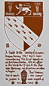
Notes: This map has the same design and text as the map shown above with two differences: the brass rubbings of figures in the top left are missing and there is no silver cross painted on by hand. The drawings in the other three corners are printed in reddish brown ink which suggests that this is a separately printed edition. I suspect that the brass rubbing in the top left corner was left off accidentally during teh second printing to add teh colours, and would have been printed in the same reddish brown ink. The proof seen has no number and is not signed. It has narrower margins to left and right.
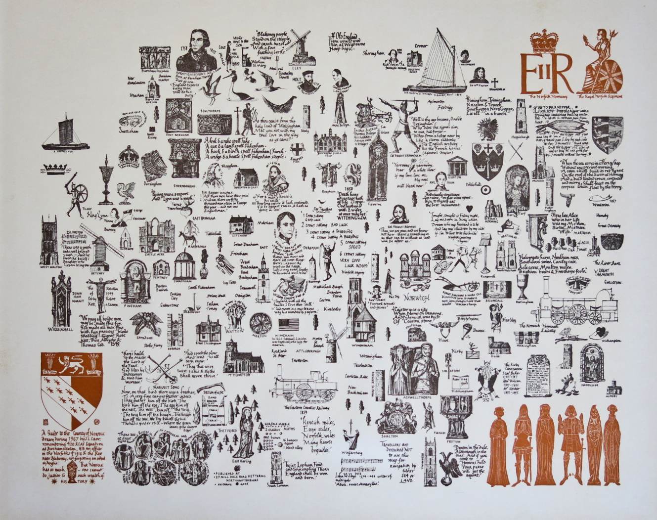
Image of map (click to enlarge)
Detail of dedication (click to enlarge)
MAP-NOR2: Second edition
Publisher: J.L. Carr, 27 Mill Dale Road, Kettering
Year: October 1969 (dated below colophon) and November 1969 (below limitation)
ISBN: 0900847085
Limitation: 500 sheets
Size: 507 x 507 mm
Paper: white card
Colophon: sun face with address and date, lower right
Signed: Yes, under limitation at base
Proofs where: Kettering Public Library (proof); AH (map & proof)
Notes: The shield is decorated in watercolours by hand.
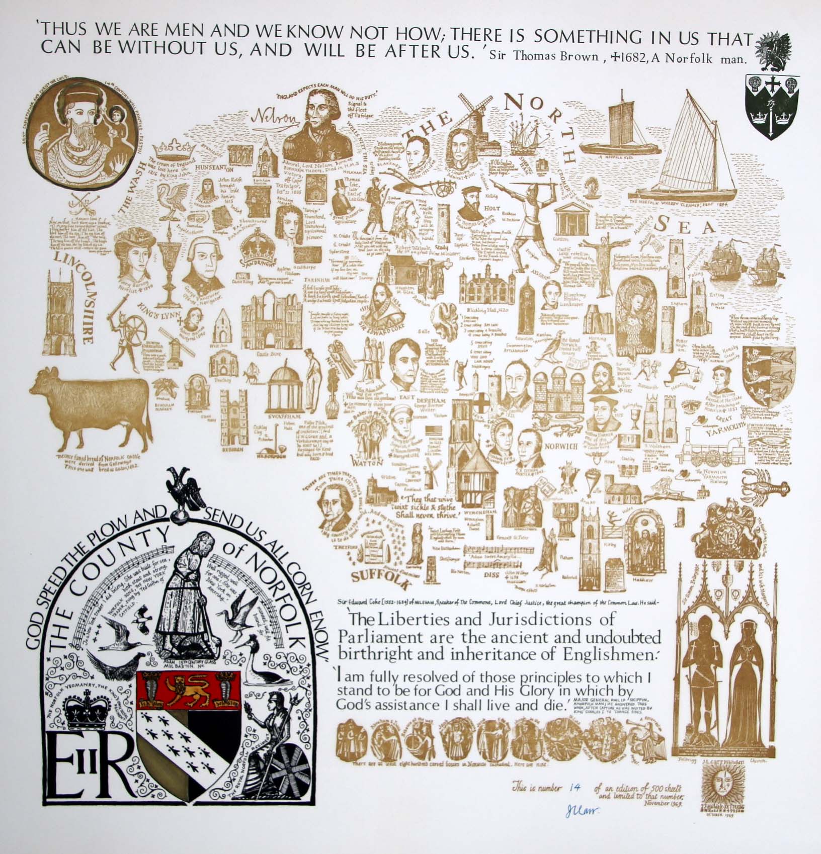
Image of map (click to enlarge)
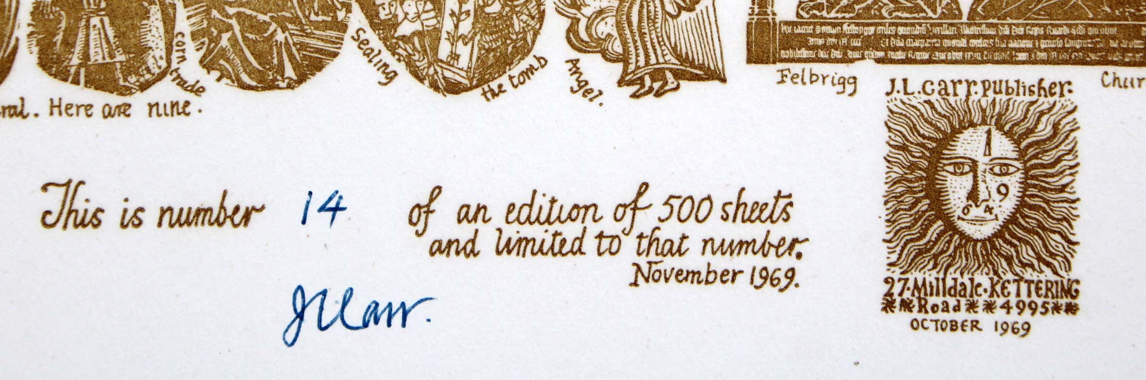
Detail of limitation (click to enlarge)
MAP-NOR3: Third edition
Publisher: J.L. Carr, 27 Mill Dale Road, Kettering
Year: 1975
ISBN: 0900847476
Limitation: 705 sheets
Size: 448 x 535 mm
Paper: thin white card
Colophon: sun face only, lower right, address to left
Signed: Yes, between limitation and colophon, at base
Proofs where: Kettering Public Library (map & proof); AH (map & proof)
Notes: The crown above EIIR is decorated in watercolours by hand.
In 2026 the Quince Tree Press were selling unsigned, numbered proofs of the same map with the same limitation on yellowish paper for £15.
Image of map (click to enlarge)
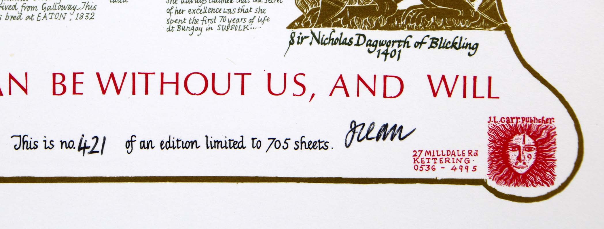
Detail of limitation (click to enlarge)